Efficiency of Aerial Drones for Macrolitter Monitoring on Baltic Sea Beaches
Efficiency of Aerial Drones for Macrolitter Monitoring on Baltic Sea Beaches
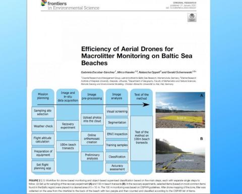
This study tests the potential of aerial drones or Unmanned Aerial Vehicles together with a Geographic Information System approach for semi-automatic classification of meso- (1–25 mm) and macrolitter (>25 mm) at four beaches of the southern Baltic Sea.
Visual screening of drone images in recovery experiments (50 m2 areas) at 10 m height revealed an accuracy of 99%. The total accuracy of classification using object-based classification was 45–90% for the classification with four classes and 50–66% for the classification with six classes, depending on the algorithm and flight height used. On 100 m beach monitoring transects the accuracy was between 39–74% (4 classes) and 25–74% (6 classes), with very low kappa values, indicating that the GIS classification method cannot be regarded as a reliable method for the detection of litter in the Southern Baltic.
In terms of cost-efficiency, the drone method showed high reproducibility and moderate accuracy, with much lower flexibility and quality of data than a comparable spatial-OSPAR method. Consequently, our results suggest that drone based monitoring cannot be recommended as a replacement or complement existing methods in southern Baltic beaches. However, drone monitoring could be useful at other sites and other methods for image analysis should be tested to explore this tool for fast-screening of non-accessible sites, fragile ecosystems, floating litter or heavily polluted beaches.
Escobar-Sánchez G, Haseler M, Oppelt N and Schernewski G (2021) Efficiency of Aerial Drones for Macrolitter Monitoring on Baltic Sea Beaches. Front. Environ. Sci. 8:560237. doi: 10.3389/fenvs.2020.560237

